|
Issued: 0530hrs Monday 29th October 2018
Duty forecaster: Garry Nicholson
Heavy snow for the southern Alps
 Monday Monday
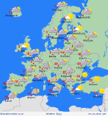
A vigorous area of low pressure over the western Mediterranean drifts north into central Europe. Prolonged heavy rain for south-eastern France and northern Italy, with heavy snowfalls across the Alps. Gale force winds are also expected, these strong winds also extending into Germany and central-eastern Europe.
Showers for northern Spain, snow over the mountains. Thundery downpours also for the Balearics, but southern Spain and Portugal should stay generally dry, highs 17C. South-east Europe toward Greece and the Black Sea will be dry and sunny, topping 25C in Hungary and Romania.
Largely dry and cool for northern Europe. Brisk easterly winds dominate as high pressure resides to the north. A few showers for southern Scandinavia. Cold for Norway, Sweden and Finland, max 3 to 5C, and northern areas staying sub-zero away from the coast.
 Tuesday Tuesday
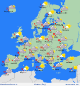
A front moves into Iberia from the west overnight, bringing rain to southern Spain, followed by a cool and showery pattern for Portugal. Northern Spain, plus the west and south of France will be generally dry.
Low pressure moves north to bring heavy rain and gales to north-east France, the Low Countries and western Germany. A risk of snow over higher ground. Rain and snow also advances north into Norway and Sweden. Gales for the Baltic Sea.
Clusters of thundery showers affect the western Mediterranean, Italy and the Balkans. Bursts of rain may move into western Greece , perhaps also reaching Hungary. The Greek Islands and areas toward the Black Sea will stay dry and warm. A waft of warm air extends north across eastern Europe, 20C in Poland.
|
